A prominent Indian modern and contemporary artist, Maqbool Fida Husain (1915-2011), suffered unwilling exile after depicting Untitled (Bharat Mata) in 2006 (figure 1). Husain’s painting Untitled (Bharat Mata) depicts the Indian subcontinent as a woman folding her body in nudity, and consequently, the Hindu nationalists charged him for violating the sacred image of the goddess (Ramaswami, 2011, 2-4). The painter made the painting as a geo-body illustration, as clear by writing names of the city, such as from north of Srinagar in Kashmir, passing through Gujarat where the massacre happened in 2002, and Bhopal where the worst chemical disaster happened, and south to Cochin and Chennai (Ramaswami, 2011, 86). The wheel used in the national flag is located in the right center, indicating India herself.
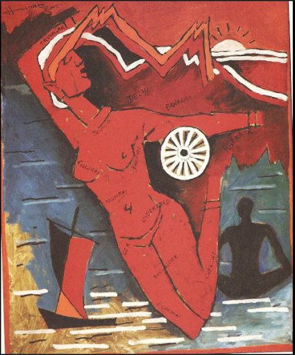
Figure 1: M. F. Husain, Untitled (Bharat Mata), Acrylic on Canvas, 41.5 x 33.5 inches, 2005.
This painting is evidently an example of geo-body, as the painter stated that “I have depicted in my works nothing but India herself.” (Ramaswami, 2011, 81) The concept of geo-body highlights its visual formation through the combination of cartographic representation and symbolic imagery. Sumathi Ramaswamy defines geo-body as “implication of cartographic visualizations for the (re)imagining of national territory,” (Ramaswami, 2002, 152) and Thongchai Winichakul, who researched the geo-body of Thailand, “a modern nation-state imagined in mapped form.”(Winichakul, 1994, 76) In India, geo-body mapping emerged during the period of formation of the nation. Nationalism requires the boundary of India, executed as a cartographic map that represents the territory of the nation, and patriot populists made mostly a Hindu goddess-like female figure as a symbolic personification of India. Husain’s use of the geo-body indebted to this product of modernism since the British colonial period in that it transforms the emblematic image of Bharat Mata that symbolizes India as a nation.
I would like to critically think about Ramaswamy’s word choice of enchanted and disenchanted in “Visualizing Geo-body: Globes, Maps, Bodyscapes.” Ramaswamy’s view on geo-body mapping is that the concept of European cartography, the scientific method of disenchantment, collaborated with the inserted enchanting image of deified and womanized Bharat Mata, evoking nationalistic sentiments and persuading the public. Ramaswamy mentions that “visual patriotism tries to solve the problem of getting Indians to die for an abstract geo-body named ‘India’ by inserting the image of Bharat Mata into the empty social space of the map of India.” (Ramaswami, 2002, 181) The geo-body of India could solidify the abstract concept of a nation through the disenchanted territory of the subcontinent and the enchanting image of the body of Bharat Mata.
However, the scientific method as disenchantment could not fully interpret the idealization desire of the mapping in the geo-body. As Matthew Edney said in his book Cartography: The Ideal and Its History, the cartography and mapping may presume the universal method and scientific efforts to see maps, but it contains particular idealization. (Edney, 2019, 233) Of course, twentieth-century Indians might have seen the mapping as scientific, but I would say the mapping was another method for an idealized image encompassing the Indian subcontinent. Indians adopted the cartography to represent India as “a modern nation” beyond a value-neutral approach and have founded its enchanting values. The enchanting features of the cartography and the goddess could be powerful as they amplify the same enchanting images.
In addition, the existing concepts that define space and authority in India are important in that they combine cartography in forming the geo-body. In Thongchai Winichakul’s Siam Mapped, the geo-body replaced the original premodern territory as a part of the royal body in Thai (Winichakul, 134). Furthermore, the conjunctions of the concept of geo-body with other communal identifications have produced expansive meanings, collaborating with local concepts on space (Winichakul, 135). Thongchai suggests that the word banmuang, a spatial meaning of city or village-city, and chat, a community that does not include spatial meaning, combined with the modern cartography functioned to convey both of those meanings (Winichakul, 134-135). Through the Thongchai’s research, although my paper will not deal with the history of mapping in India, the cartography could have a consecutive meaning with painting and visual culture in India. As seen in Ramaswamy’s article, the Indian map collaborates with the painting and authority of the emperor (Ramaswami, 2002, 160). The formation of the geo-body has to do with the painting, and the cartography in India should be considered encompassing the desire of authority in paintings.
Husain employed the visual languages of the cartography and Bharat Mata in distinct ways. He adopted painting techniques traditionally used for creating enchanting imagery; yet his Bharat Mata is deliberately disenchanting, neither romanticized nor idealized vision. His depiction of Bharat Mata dismantles the authority the nation had accumulated over a century, showcasing tough realities instead. In other words, through the depiction of the geo-body, Husain created an inconsistency between the ideal image of Bharat Mata and the representation of India. Husain explicitly depicted this rupture in his 2005 Bharat Mata, distinguishing it from his earlier paintings. His earlier representations of Bharat Mata (figure 2), depicted wearing clothes, do not expose India’s reality; rather, they continue the early twentieth-century image of depicting the nation’s colonial defiance, such as Gandhi’s procession. In contrast, Husain’s work from 2005 fully deconstructed this narrative, portraying the nation as a place of suffering and pain.
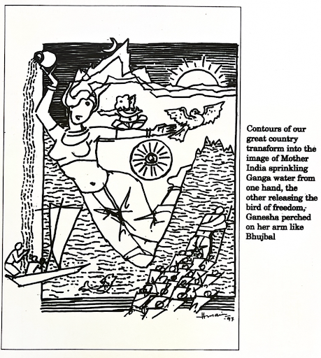
Figure 2: M. F. Husain, Central Panel of 50 Years of Emerging India: A Triptych. Illustration in The Times of India, Special Supplement, Bombay, 15 August 1997. Image scanned from Barefoot across the Nation: Maqbool Fida Husain and the Idea of India, edited by Sumathi Ramaswamy.
Indeed, Husain’s Bharat Mata was a provocative depiction of India itself. He attempted to enchant India’s “real” image by projecting his ideas on the geo-body. From my retrospective view, the controversy surrounding the depiction of nudity was a minor problem. The geo-body was inseparable from national authority in the process of circulating as a popular image in Indian visual culture and later as fine art. However, Husain dethroned the geobody from its divine realm, where deities and national patriarchs reside, into the tangible, visible reality of the nation’s difficulty that Indians could observe with bare eyes. If Indians justified Husain’s aesthetic attempt on the geo-body, it would undermine the Hindu nationalist perspective, which asserts national legitimacy by appropriating and taking the nationalism through Bharat Mata formed during the colonial period. Hindu nationalists seem to have failed to articulate this gap fully, but they seized on the issue of nudity to tarnish Hussain’s reputation.
The judicial decision did not play a crucial role in determining the appropriateness of Husain’s work, nor in addressing the charge of nudity. Instead, what was truly important was to know how the painter disrupted the enchanted Bharat Mata into the realm of disenchantment. The judge’s objective statements did little to alter Husain’s situation, merely demystifying Husain’s effort to create a tension of coexisting enchanted and disenchanted images. Thus, it did not impose any damage on the Hindu nationalist’s assault on his painting. In a context where the enchanting accusation through art is being demystified, what Husain needed was not a judicial judgment but the proliferation of more compelling and enchanting images of real India.
Bibliography
Edney, Matthew H. Cartography: The Ideal and Its History. Chicago: The University of Chicago Press, 2019.
Ramaswamy, Sumathi. “Introduction: Barefoot Across India–An Artist and His Country.” In Barefoot across the Nation: Maqbool Fida Husain and the Idea of India, by Sumathi Ramaswamy, 1–20. edited by Sumathi Ramaswamy. Visual and Media Histories. New York: Routledge, 2011.
———. “Mapping India after Husain.” In Barefoot across the Nation: Maqbool Fida Husain and the Idea of India1, by Sumathi Ramaswamy, 75–99. edited by Sumathi Ramaswamy. Visual and Media Histories. New York: Routledge, 2011.
———. “Visualising India’s Geo-Body: Globes, Maps, Bodyscapes.” Contributions to Indian Sociology 36, no. 1–2 (February 2002): 151–89.
Thongchai Winichakul. Siam Mapped: A History of the Geo-Body of a Nation. Honolulu: University of Hawaii Press, 1994.
This essay was written for the NYU Institute of Fine Arts course, “From Mapping to Mapmakers,” taught by Prof. Dipti Khera